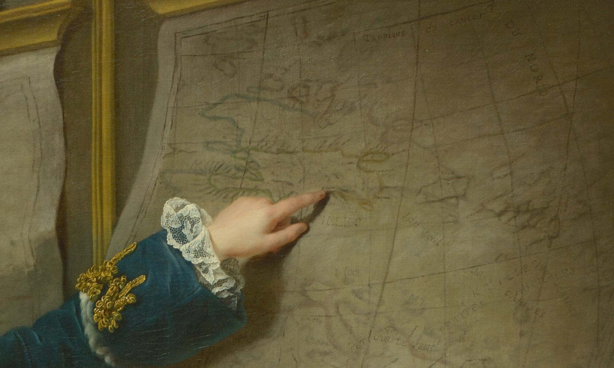
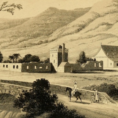
In the final years of King Henry Christophe’s reign over northern Haiti (r. 1811–20), a Black man arrived at Christophe’s royal court in the opulent palace of Sans-Souci. He sought artistic instruction under British painter Richard Evans at the recently established Academy of Painting and Drawing. To reach the Academy, the aspiring artist would have traversed a landscape still carrying the memory of the Haitian Revolution (1791-1804). He would, years later, render the ruins of plantations which lined the surrounding roads (Fig. 1).
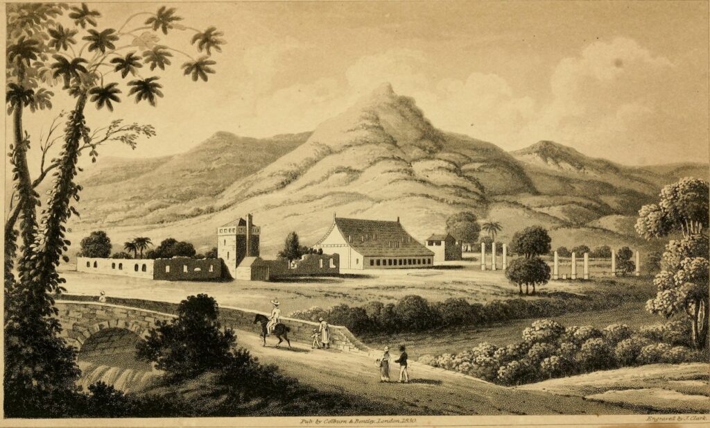
Fig.1. John Heaviside Clark (after an artist once known), “La Victoire ci-devant Grand Pré, on the Road to Sans Souci,” c. 1827. Lithograph published as the frontispiece to Charles Mackenzie’s Notes on Haiti: Made during a Residence in That Republic (1830). Image source: Wikimedia Commons.
The man’s artistic education was short-lived. Amid growing popular unrest, Christophe took his own life in his bedchamber at Sans-Souci in 1820. This cataclysmic event shuttered the Academy, and the curtains fell on Christophe’s kingdom. Yet the artist continued to reside in the region after Christophe’s downfall and produced new works of art. In 1827, two of the artist’s now-lost drawings were taken to England and made into lithographs by Scottish printmaker John Heaviside Clark. These lithographs appear in an 1830 memoir titled Notes on Haiti authored by Charles Mackenzie, who had served as Consul General of Haiti between 1825 and 1827. Mackenzie offers only a single acknowledgment of the today-unknown Black man’s contribution of the only two illustrations included in his ambitious six-hundred-fifty-page work: “The individual who made the sketches which are engraved in these volumes, is a native Haitian, who owed all his instruction to the institutions of the king.”[1]
Mackenzie frames Notes on Haiti as an objective report on Haiti’s social and political conditions, but his motives were overtly ideological. In the book’s preface, Mackenzie claims that his earlier reports had been used to describe Haitian society and its leadership favorably—prompting him to publish a scathing and often overtly racist rebuttal.[2] Mackenzie fills his text with gruesome accounts of the atrocities committed by Black leaders both during and after the Revolution while conspicuously omitting any mention of the violence of slavery. Mackenzie furnishes his visit to Christophe’s palace with particular prominence within the book, writing that the edifice was a “place in which, I believe, for a time, more unlimited despotism had been exercised than has ever prevailed in any country aspiring to Christianity and civilization.”[3] Within a narrative that relentlessly discredits the capacity of Black people for self-governance, it is striking that an artist who worked under Christophe created the book’s sole visual representations of the country.
Mackenzie’s book includes two scenes: one depicting Sans-Souci and the other showing a road passing alongside the partial ruins of a former plantation (Fig. 1). As one of the most talked-about edifices in the world at the time of its construction, the image of Sans-Souci represented a predictable selection. However, the lithograph of the ruined sugar plantation adjacent to Sans-Souci initially appears incongruous. Mackenzie only makes a passing and imprecise reference to the plantation in his text: “We traveled over a tolerably good road, through the ruins of sugar plantations, of one of which the plate gives a very accurate representation.”[4] Even if Mackenzie requested an image of an abandoned sugar plantation, the decision to depict La Victoire likely belonged to the artist. What was his intention in drawing this scene?
The artist likely selected the site in reference to a key event in Christophe’s rise to power. In the final years of the Haitian Revolution, Christophe’s military rival Jean-Baptiste Sans-Souci—an ethnically Kongo rebel leader—rose to prominence between 1802 and 1803. Sans-Souci amassed a wide, primarily African-born following and thus challenged the emerging post-revolutionary political hierarchy led by Christophe, Jean-Jacques Dessalines, and Alexandre Pétion. Although Sans-Souci had pledged his allegiance to Dessalines, Christophe lured Sans-Souci to his camp on the Grand Pré plantation and murdered him—an act which consolidated Christophe’s power.[5] The title of the work, “La Victoire, formerly Grand Pré,” explicitly articulated that the plantation’s current name had changed from that which we can distinguish on René Phelipeau’s map. The renaming of an abandoned plantation may appear illogical, but the choice of a name that can be translated as “The Victory” for the precise location where Henry Christophe defeated Sans-Souci was almost certainly calculated. While the moment of Christophe’s triumph is not visually represented in the lithograph, the site evidently served as a monument to his victory. When paired with the drawing of the palace of Sans-Souci, the scene forms a diptych demonstrating Christophe’s authority, even years after his death.
The renaming of the abandoned plantation is just one example of the ways in which Haitians remapped the plantation terrain after the end of the Revolution, exerting their control over the landscape and eliminating signs of French colonial rule. This transformation commenced with the nation’s name: Saint-Domingue would be re-baptized Ayiti, the island’s Indigenous Arawak name, meaning “land of mountains.” Christophe also baptized the wealthy port city near his palace (formerly called Cap-Français) Cap-Henry in his honor. Yet the Haitian artist not only invoked the changing of a social order away from white supremacy in the lithograph’s title—he also showed it in the scene itself.
The lithograph of the artist’s drawing presents a striking departure from the plantation’s appearance under slavery. The image shows a babbling brook with an arched stone bridge, a woman patiently accompanying a child along a road, and the poetic backdrop of hills. Likely drawing on Evans’ artistic instruction, the artist uses the familiar visual tropes of the English countryside to portray a bucolic Haitian landscape. The Black figures walking by the plantation on the road are occupied with conversation, the restraint of a rambunctious child, and travel on horseback: not a single figure pauses to gaze at the ruined plantation buildings to their right, their bare terrain devoid of the quotidian labor of the plantation. The figures’ apparently uninhibited mobility represents an act of freedom incompatible with Haiti’s slaveholding past. In the hands of the Haitian artist, the plantation transforms from a relic of slavery to a backdrop to Black freedom.
Cite this post as: Sophia Kitlinski, “Drawing the Legacy of Henry Christophe,” Colonial Networks (June 2025), www.colonialnetworks.org/?p=835.
[1] Charles Mackenzie, Notes on Haiti: Made during a Residence in That Republic, vol. 1 (London: H. Colburn and R. Bentley, 1830), 158. Mackenzie consistently uses the term “native” to refer to anyone born in Haiti, with the implicit understanding that a “native Haitian” would be Black; he refers to exceptions as “native whites.”
[5] Michel-Rolph Trouillot contends that Christophe’s palace was named after Jean-Baptiste Sans-Souci. Trouillot links Christophe’s selection of the location and name of his abode to a practice in the West African kingdom of Dahomey, located in what is today Benin. There, military leaders founded their palaces in locations where important enemies had been defeated and killed and then baptized the edifice with their names, part of a “transformative ritual to absorb [their] old enemy.” See Trouillot, Silencing the Past, 2nd ed. (Beacon Press, 2015), 211.
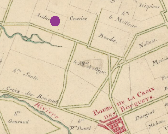
Fig. 1. Lilavois Plantation marked on detail of Charles-François Hesse, Plan of the plain of Cul-de-Sac in Port-au-Prince, island of Saint-Domingue surveyed, c. 1780. Source: gallica.bnf.fr / Bibliothèque nationale de France.
In 1786, an enslaved man called Jean-François escaped from the Lilavois plantation, where this marker is located (Fig. 1). A reward was offered for his capture in the Saint-Domingue newspaper Affiches américaines, which regularly published advertisements for enslaved “runaways” (maroons). From this ad we learn, among other things, that Jean-François was an accomplished wigmaker.
Wigs (perruques) were a ubiquitous fashion item in both metropolitan and colonial France. Originally associated with aristocrats, by the mid-eighteenth century they were widely worn by merchants, artists, and other professionals, like the Saint-Domingue slave trader Stanislas Foäche, who found them both practical and vital as a means of self-expression. Shops selling all manner of wigs proliferated in Paris and in other metropolitan cities like Le Havre and Nantes, as well as in the Saint-Domingue towns of Port-au-Prince and Cap-Français (now Cap Haïtien). Wigmakers or perruquiers also worked in theaters and domestic residences, where hairdressing was an intimate daily task typically performed by servants.
Hundreds of enslaved men and (less often) women were identified as wigmakers in two period sources: government records documenting the entry of persons of color into metropolitan France; and newspaper advertisements for fugitive slaves like the one posted for Jean-François. Regarding the former, since French colonists had to justify bringing enslaved men and women to the metropole, many claimed they were planning to instruct these individuals in the art of hairdressing, which they could then practice once they returned to the colonies. Such a claim, specious or not, would not have been questioned by Crown authorities, given the popularity of wigs and the fact that the latest trends originated in France.[1]
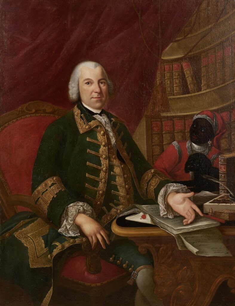
Scores of young men were brought from Saint-Domingue to France for the supposed purpose of learning this métier. One such man was “Laurent,” a fourteen-year-old creole who arrived in Paris in 1762 and was portrayed alongside his white enslaver, Mlle Desgots.[2] Another was “Polidor, called Joseph after baptism,” a twenty-year-old man originally from Sierra Leone who was recorded (in 1748 and 1762) as being “owned” by the Deurbroucq family, prominent colonial traders in Nantes.[3] A 1753 portrait of the merchant Dominique-René Deurbroucq and an African servant wearing a prominent metal collar (possibly Polidor/Joseph himself) gives a sense of the appearance and role of enslaved domestics who may have been forced to practice hairdressing among their many duties (Fig. 2). Following the conventions of this portrait type, it uses strong color contrasts to accentuate the difference—and suggest a racialized power dynamic—between Deurbroucq, with his pale skin and white powdered wig, and his Black servant and dog. Powdered wigs, as Angela Rosenthal has shown, amplified these racist divisions by highlighting the supposedly superior whiteness of European wearers, and by pitting their controlled tresses against the dark, “allegedly unkempt” hair associated with Africans.[4]
Such categories were brutally enforced but also subverted in Saint-Domingue. White colonists wore powdered wigs, but so too did free persons of color, sometimes to indicate their membership in the elite planter class.[5] The contrast between a white powdered wig and dark skin, as evoked in a 1788 portrait of the Chevalier de Saint-Georges (a mixed-race composer born in Guadeloupe), may have challenged racial hierarchies by underscoring how wigs, and the supposedly superior values they connoted, could be acquired or performed regardless of race. Many prominent members of the free Black community in Saint-Domingue also established themselves professionally as wigmakers, most notably Jean-Baptiste Belley, who lived in the town of Cap-Français and was identified as a perruquier in notarial and parish registers.[6] Some of these free Black wigmakers, including Belley, may have learned the art of hairdressingas former slaves, perhaps using their skills to obtain their freedom.
Based on advertisements in the Affiches américaines, wigmakers represented the second highest occupational category of enslaved escapees from plantations in the pre-Revolutionary period. These inhabitants may simply have had greater means to escape (since they likely lived in the main residence and needed to travel to town for supplies), but they may have also recognized the demand for their craft and the possibilities it afforded. One such escaped wigmaker, mentioned at the beginning of this essay, was a mixed-race man known as Jean-François. An ad published in the Affiches on April 5, 1786 claims that he had formerly been apprenticed to a Port-au-Prince perruquier named “sieur Montreal,” but at the time of his escape had been residing at Mare-à-Daniel, a plantation partly owned by M. Lilavois. The ad further describes Jean-François as having “lively eyes” and “sunken cheeks,” and it notes that he could play the horn and speak Spanish but says nothing about his hair. It does, however, warn readers that he was “perhaps calling himself free”—suggesting his decision to self-emancipate and cast off the dehumanizing yoke of enslavement like an old wig.
[1] Jennifer L. Palmer, “Atlantic Crossings: Race, Gender, and the Construction of Families in Eighteenth-Century La Rochelle” (PhD dissertation, University of Michigan, 2008), 262.
[2] Julia Doe, “Musical Sociability, Atlantic Slavery, and the Portraiture of Carmontelle,” The Journal of Musicology 41, no. 1 (2024): 1-40.
[3] Érick Noël et al., eds., Dictionnaire des gens de couleur dans la France moderne, 3 vols. (Geneva: Libraire Droz, 2001), 1, n. 446; and 2, n. 2775.
[4] Angela Rosenthal, “Raising Hair,” Eighteenth-Century Studies 38, no. 1 (Fall 2004): 2. See also Palmer, “Atlantic Crossings,” 262.
[5] Stewart R. King, Blue Coat or Powdered Wig: Free People of Color in Pre-Revolutionary Saint-Domingue (Athens: University of Georgia Press, 2001).
[6] Jean-Louis Donnadieu, “Derrière le portrait, l’homme: Jean-Baptiste Belley, dit ‘Timbaze’, dit ‘Mars’ (1746?-1805),” Bulletin de la Société d’Histoire de la Guadeloupe 170 (January-April 2015), 29-54, dit.org/en/journals/bshg/2015-n170-bshg01792/1029391ar.pdf
Elisabeth Alexandrine Louise Ferrand, known as “Minette” (1767-1807), was an actor-singer of mixed racial ancestry.[1] She and her half-sister, Lise, are the only two performers of color known to have appeared on the Saint-Dominguan stage whose names have made their way down to us.[2]
Minette was born and raised in Port-au-Prince and her first public appearance, when she was only 13 years old, was as a soloist in a Christmas concert in 1780 at the local playhouse. The announcement in the Supplément auxAffiches américaines newspaper does not name Minette but refers to her respectfully, if also somewhat coyly, as “une jeune Demoiselle” (a young lady), noting that she will sing “plusieurs Ariettes dans le grand genre, & plusieurs Duo” (i.e. solos and duets from various opéras-comiques). Minette’s first full theatrical performance was in a benefit performance organized by her mentor, the actor-singer Mme Acquaire (née Dézi), in Port-au-Prince on 6 March 1781. Minette took the soprano role of Isabelle in the opéra-comique, Isabelle et Gertrude (by Blaise and Favart), which featured in a double bill alongside the Créole parody, Thérèse et Jeannot.
In the newspaper advertisement announcing this performance, Minette is referred to again as “une jeune Demoiselle,” and her age is wrongly given as 14 years (she was still only 13). In Moreau de Saint-Méry’s retrospective account of this event, he does not comment explicitly on Minette’s racial ancestry, but refers to her as “une jeune personne” (a young person rather than a young lady)—an epithet that was also used near the beginning of Minette’s career in the press, where she was subsequently referred to as “la jeune personne” (the young person) and later as “Demoiselle Minette”. Moreau de Saint-Méry notes that the young performer was “créole” (i.e. born locally) and indicates that her exceptional talents enabled her to overcome (unspecified) colonial prejudices. The launch of Minette’s career was facilitated by the then director of the Port-au-Prince playhouse, François Saint-Martin (died 1784), who may also have been Minette’s life partner.
Minette’s signature on the baptismal record of her third child. Archives nationales d’outre mer (France), Regsitres paroissiaux, Port-au-Prince, 1790, fol. 48 (8)2.
This debut marked the beginning of a successful, if also somewhat erratic, solo career at the Port-au-Prince playhouse that lasted until 1789. During this time, Minette performed a wide range of roles, most of them in opéras-comiques—a genre combining sung and spoken elements and the most popular form of theatre in the colony. Minette participated in subscription performances as a regular member of the Port-au-Prince troupe; like other troupe members, she also organized occasional benefit performances where she was free to choose her own repertoire. Roles taken by Minette included Lucette in Grétry and Marmontel’s Silvain, Miris in Monsigny and Sedaine’s La Belle Arsène, Robinette in Duni and Favart’s La Fée urgelle, Zémire in Grétry and Marmontel’s Zémire et Azor. Interestingly, when announcing her upcoming benefit performance in 1787 in which she would perform the demanding title role in Dalayrac and Marsollier’s Nina, Minette addressed the locals in the Port-au-Prince theatre audience and reminded them of their shared status as créoles.[3] In addition to her many roles in opéras-comiques, Minette played Galathée in Rousseau’s melodrama, Pygmalion; Cupid in Gluck’s opera seria, Orphée et Eurydice; and, seemingly, the (spoken) trouser role of Chérubin in a performance of Beaumarchais’s Le Mariage de Figaro.[4]
Minette’s final documented performance in Port-au-Prince was as herself in a metatheatrical work by the editor of the Affiches américaines, Charles Mozard, whose La Répétition interrompue was written as a local response to news from France about the French Revolution. Performed on 4 October 1789, the work responds specifically to—and purports to celebrate—the unification of the three (social) orders or estates, which led to the creation of a National Assembly.
The fact that Minette was not given a solo role in La Répétition interrompue is a telling reminder of the precarious nature of her social position as a successful performer of color in a theatrical world—and wider society—that was dominated by white people, particularly at a time of social change. However, it is important to acknowledge, too, the fact that Minette, as a free person of color from a relatively privileged background, belonged to a slave-owning community.
Minette’s mother owned a house with a slave hut, and there is evidence to indicate that Minette herself was also an enslaver: in 1786, a man named Longuet left Minette two enslaved young women in his will and, in February 1790, a jail list in the Affiches américaines includes “Isidore, se disant appartenir à la Dlle Minette” (Isidore, claiming to belong to Mlle Minette). The purpose of such a list was for enslavers—or their representatives—to go to the jail and reclaim and re-enslave their human “property”.
Research into Minette’s life and career, particularly during the revolutionary and post-revolutionary period, is ongoing. However, we know that she performed in Baltimore in 1796 and gave birth to a daughter in Philadelphia later that year. Minette was back in Saint-Domingue in 1799 and appears to have travelled to Cuba in 1802. She ended up in New Orleans, where she attempted to pursue her performing career but was dogged by ill-health and died in 1807. Minette’s fascinating and complex life has been fictionalized in a novel by the Haitian writer Marie Vieux-Chauvet, La Danse sur le volcan (1957; 2008) (translated into English by Kaiama Glover in 2016), and, more recently, in a play, Placeholder, by Catherine Bisset (2023) (translated into French with Haitian Kreyòl by Elise Finielz).
[1] For more on Minette’s ancestry, see Bernard Camier, “A ‘Free Artist of Color’ in Late-Eighteenth-Century Saint-Domingue: The Life and Times of Minette,” Music & Musical Performance: 1. Available at: https://digitalcommons.fiu.edu/mmp/vol1/iss1/1.
[2] For more on performers of colour, including enslaved performers, in the theatres of Saint-Domingue, see Julia Prest, Public Theatre and the Enslaved People of Colonial Saint-Domingue (Cham: Palgrave Macmillan, 2023), chapter 5, pp. 153-87.
[3] For more on the significance and dynamics of Minette performing this role, see Julia Prest, “Parisian Palimpsests and Creole Creations: Mme Marsan and Dlle Minette perform Nina on the Caribbean Stage,” Early Modern French Studies 41.2 (2019), 170-88. Available at https://www.tandfonline.com/doi/full/10.1080/20563035.2019.1592813.
[4] Details of all performances documented in the local press can be found at https://www.theatreinsaintdomingue.org.
The playhouse most closely associated with the town of Port-au-Prince during the colonial era was built in 1777 and inaugurated with a performance of Martini and Durosoy’s Henri IV, ou la Bataille d’Ivry on 1 January 1778. However, public theatre also existed in Port-au-Prince prior to this date. There is occasional evidence of professional theatrical activity in the 1760s, including newspaper advertisements for performances in 1767 and 1768. On 29 January 1772, the Affiches américaines newspaper announced an upcoming event on 2 February to mark the (re)opening of the local theatre with newly-arrived actors performing Regnard’s Les Folies amoureuses and the opéra-comique, Annette et Lubin (by Favart and Blaise). It is not until 1777 that announcements for upcoming performances in Port-au-Prince become frequent—in the year prior to the opening of the so-called Mesplès playhouse.[1]
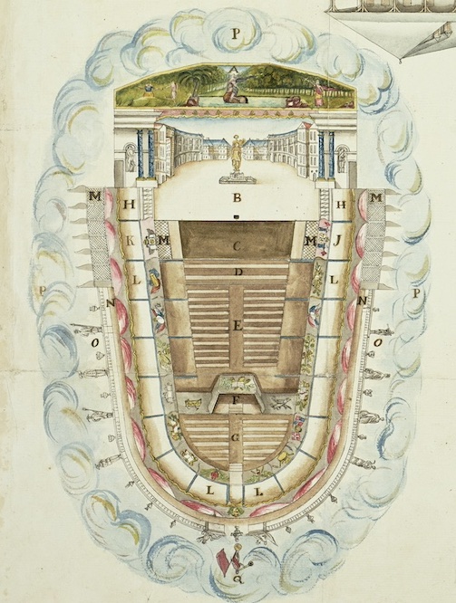
François Mesplès and his associate, Lasserre, were businessmen rather than theatre enthusiasts, and they were persuaded to build a playhouse on the place Vallière in Port-au-Prince because the agreement also involved the construction of a number of other buildings that could be used as businesses or dwellings. A set of detailed architectural drawings showing the place Vallière site (and another at the l’islet de l’Horloge) drawn up after the fact provide valuable information about the design of this wooden playhouse (by contrast, the bigger, grander playhouse in Cap-Français was made of stone). The seating plan features designated seating areas for several groups including colonial administrators and officers from the local garrison. In addition to the ground-level, the theatre had two tiers of boxes.
Plans for the Port-au-Prince Playhouse, showing seating plan of auditorium and elevation-perspective of stage (1782-1783). Archives nationales d’outre mer (France), FR ANOM F3 296 E75.
Of these, fifteen of the second-level boxes at the back and along the side of the playhouse were designated as being “pour les gens de couleur” (for the free people of color). With an average of seven people in each box, the theatre could hold around 105 free people of color, i.e. approximately 14% of its full capacity of around 750 spectators. This policy of segregation, even supposing that it was enforced, does not mean that people from different social groups did not mix at (or en route to) the playhouse in Port-au-Prince. All spectators entered the building via the same narrow entrance, and (white) audience members seated in the first row of boxes used the same staircases as the free people of color who continued up another flight. Indeed, one argument put forward in the 1780s in favor of building a new playhouse was precisely the wish (on the part of some white audience members, at least) to have separate entrances.
What the drawings do not show is any space for enslaved people. While enslaved domestic servants who accompanied their “masters” to the playhouse did not have a designated seating or standing area, they will have spent time in the playhouse’s narrow corridors and even, when summoned, in the boxes themselves. They will sometimes, therefore, have overheard (and even overseen) portions of the works performed. Enslaved people in the playhouses of Saint-Domingue have been called “mitigated spectators”—mitigated because their access to the works was limited and mitigated, above all, because they were not there by choice. Although enslaved people are invisible in the theatre drawings, it is possible that they outnumbered the free people of color present.[2] Also difficult to discern are the diverse contributions made by enslaved people to other aspects of theatre-making. These include the work of assistant painters who helped with the stage sets, that of male and female hairdressers who prepared the actors’ wigs and the seamstresses who sewed and repaired the costumes.[3]
The Port-au-Prince theatre was not always a profitable enterprise, but it enjoyed hundreds of performances of opéras-comiques, comedies and works belonging to other genres from the late 1770s up to mid-November 1791. The Mesplès playhouse was where the local performer of mixed racial ancestry, Minette, made her name singing solo roles in the particularly popular genre of opéra-comique (featuring spoken and sung elements). A (then) enslaved violinist called Julien, who later enjoyed a successful musical career as a free man in France under the name Louis Julien Clarchies, performed a series of duets alongside a white violinist during a theatrical event in Port-au-Prince in 1783. Meanwhile, Mesplès’s long-serving enslaved domestic servant and skilled handyman, Louis, was the go-to person for any minor repairs to his buildings, including the playhouse.
When news of the French Revolution reached Saint-Domingue in September 1789, the editor of the Affiches américaines, Charles Mozard, hastily composed a metatheatrical response called La Répétition interrompue, which is set in the very playhouse in which it was performed on 4 October 1789. The work includes valuable, often satirical, references to theatre-making in that space, including the role of the prompt, and procedures for rehearsing.
The slave revolts near Cap-Français that marked the beginning of the Haitian Revolution took place in August 1791. This led to civil unrest elsewhere in the colony, and in November 1791 a fire in Port-au-Prince destroyed, among other buildings, the Mesplès theatre. During the so-called Haitian revolution, theatrical activity was, unsurprisingly, sporadic at best, but there is evidence of public performances having taken place in Port-au-Prince after 1798 (when the pro-slavery British left the colony) and ongoing in 1802 on another part of the place Vallière. By this time, Saint-Domingue was no longer a slave society but now fighting for its full independence to ensure that this would remain the case.
[1] Details of all performances documented in the local press can be found at https://www.theatreinsaintdomingue.org.
[2] For more on audiences, including “mitigated spectators”, see Julia Prest, Public Theatre and the Enslaved People of Colonial Saint-Domingue (Cham: Palgrave Macmillan, 2023), chapter 2, pp. 17-50.
[3] For more on these contributions, see Julia Prest, Public Theatre and the Enslaved People of Colonial Saint-Domingue, chapter 5, pp. 153-87.
Mary Pedley (William L. Clements Library, University of Michigan)
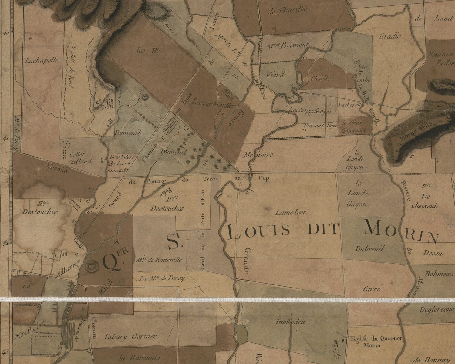
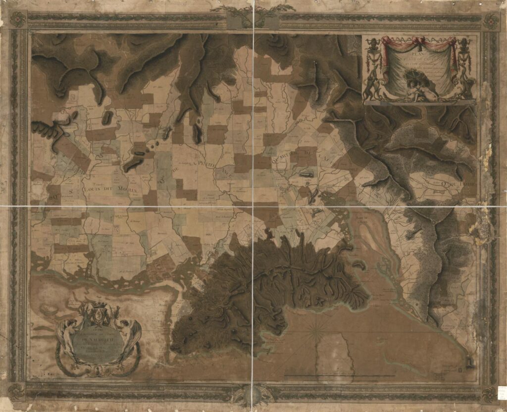
The map entitled Plan de la plaine du Cap François en l’Isle St. Domingue is a fascinating example of cartographic composition and engraving skill (Fig. 1). It combines the measured detail of property surveys, the shaded values of topographical depiction, the soundings and nautical codes of a marine chart, and the presentation attributes of the print world in its ornate dedication and title cartouches and decorative frame. The seductive beauty of the map lies in aesthetic qualities that reinforce a claim to veracity and even accuracy. To assess such a claim, we must ask the basic questions of a primary source: who made it, where and when, by what method, for whom, and for what purpose.
Fig. 1. René Phelipeau, Plan of the plain of Cap Françaison the island ofSaint-Domingue, 1786, etching and engraving, 92 x 117 cm. Source: Library of Congress, Washington, D.C., https://www.loc.gov/item/73695940/.
Reading the Map
The Plan de la Plaine du Cap françois is a large map, nearly 82 by 104 cm (2 ½ by 3 feet). It was published in two versions, one printed within an engraved decorative frame, and one printed without the frame, or trimmed very closely.[1] A trompe l’oeil cartouche in the top right displays the title on a draped curtain supported by monkeys on either side; two additional monkeys join snakes slithering up the supports, and two allegorical female figures recline in the shade of a parasol. The full title reads: Plan de la Plaine du Cap françois en l’Isle St. Domingue, Rédigé d’après les dernières Opérations Geometriques Des Ingénieurs du Roy Par René Phelipeau, Ingénieur Géographe A Paris 1786. (Plan of the plain of Cap Français on the island of Saint Domingue, edited according to the latest geometrical operations of the engineers of the King by René Phelipeau, Geographical Engineer, at Paris 1786.) A further ornate cartouche at the bottom left, comprising a coronet and coat of arms flanked by nude winged figures, frames the dedication to the comte de Vaudreuil, that is, Joseph Hyacinthe François de Paule de Rigaud (1740–1817), a Paris-based courtier and art collector whose father had been the colonial governor of Saint Domingue.
The bottom left corner also includes the letters A.P.D.R. (Avec Privilege du Roi), indicating royal copyright protection, and underneath that is “Rue St Jacques No. 45,” Phelipeau’s Paris address, implying that the map could be acquired there.[2] At the center bottom the scale is indicated: approximately 1:28,000, which is a standard military map scale of the period (ca. 2 ½ inches to a mile). The geodetic coordinates of Cap François are given in the margins: “Longitude Occidentale 74d 38m 25s du Meridien de Paris,” and “Le Cap a l’Eglise 19d 46m 24d Latitude Nord.” A compass above the scale bar shows us that the map is oriented to the south; thus north is at the bottom of the map.
The contents of the map depict three layers of information about the space around the city of Cap François: first, the land as physical space of mountain, plain, rivers, and watersheds, with the sea marking its coastline; second, the land as property bounded and claimed by named proprietors; and third, the city’s place on the globe, determined by its coordinates of longitude and latitude. The mapmaking techniques of lines, dots, numbers, words, and symbols render these layers visible. The manual addition of color after printing further clarifies the content. For example, the sea is differentiated from land in two ways: soundings (numbers representing depths, usually in fathoms or six feet) are placed in the bay of Cap François and to the east near the Bourg de l’Embarcadère de Limonade; dotted lines outline the shoals of both the bay of Cap François and the bay further to the west of Acul. A pale green was added to all copies so far observed to outline the coast.
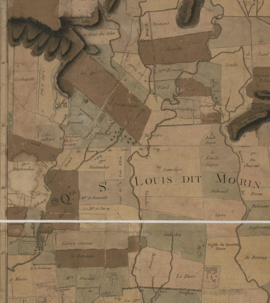
Fig. 2. Detail of Fig. 1.
On land, line work assumes a different function. Dotted straight lines show the boundaries of property ownership of the habitations (plantations), most probably of sugar production, a product implied rather than shown. At higher elevations, coffee would have been cultivated. On some habitations, dots and squares represent the main house, outbuildings, and quarters for enslaved workers, representations that could be specific to a particular habitation or generic, as most sugar plantations followed a standard arrangement of structures to increase productivity (Fig. 2). Words provide the names of putative owners. Ongoing research for this project aims to determine whether these were in fact the owners in 1786, the date of the map, or whether a habitation name reflects a former owner or serves as a place name. Social status is shown by an owner’s title (e.g. le Cmt de Vaudreuil, Le Mqs de Paroy, Cte de Raynaud de Villevert, Chr de Lacombe); gender may be noted (e.g. Mme Bremont, Mme la Vi[comtess]e de Castellane, Vve Blanfossé); and the status of a free person of color of either gender by the designation of “n.l.” for “négre libre” or “négresse libre” (e.g., Nicolas n.l., Rose n.l.)
Hachures (short engraved lines) are used to show elevation of the physical landscape: lines that are closer together depict steeper slopes, creating a shaded effect in engraved printing. If watercolor is added, it emphasizes the shading. Summits, which appear white, are left free from linework to emphasize the height. Rivers and creeks are engraved with sinuous lines—parallel lines for larger rivers, and single lighter lines for smaller creeks and rivulets. A variety of parallel lines differentiate properties: some are unbroken, some are dotted, some are a thicker line paired with a lighter line. As there is no key, we can surmise that these may not only show property boundaries but also irrigation ditches or canals, a vital part of sugar production, and a shared investment by property owners.
The Author
René Phelipeau (1752 – ?) signs himself as “ingénieur géographe” in the title and as “géographe” in his dedication to Vaudreuil. In neither case does he append “du roi” to this style, so he was not a member of the ingénieurs-géographes du roi (geographical engineers of the king), who belonged to a specialized corps that were subsidized by the royal purse from the time of Louis XIV, and whose charge was to create topographical maps of military and strategic importance for the King and his army.[3] As an independent geographer or engineer or both, he was either self-taught or instructed by an elder who trained him in design and presentation, measuring and scale.
Whether Phelipeau ever worked in Saint Domingue is a mystery. A specialized group of ingénieurs géographes were sent to the island in the 1760s to perform large scale topographical surveys on orders from the ministry of the Marine, the department of state responsible for overseas colonies.[4] Phelipeau’s name is not among them, nor is it among the engineers responsible for fortifications and infrastructure on the island. Nor is he mentioned as a local surveyor (arpenteur), who performed property surveys of individual habitations or localities, surveys used in property sales, lawsuits, inheritances, and other legal situations.
Fig. 3. Title page and table of prints. From Ponce, Moreau de St Méry, and Phelipeau, Recueil de vues des lieux principaux de la colonie françoise de Saint-Domingue…, Paris, 1791. Source: BnF/Gallica, https://gallica.bnf.fr/ark:/12148/btv1b52510633h.
In addition to Phelipeau’s large wall maps are twelve printed smaller plans of port cities in Saint Domingue, which were available separately (each has an address in Paris) or gathered into the Recueil de vues des lieux principaux de la Colonie Françoise de Saint-Domingue, gravées par les soins de M. Ponce, accompagnées de cartes et plans de la même colonie, gravés par les soins de M. Phelipeau….. Paris, 1791. (Fig 3). They are similar in size, scope, style, and content. Dated 1785 are plans of Leogane, Port au Prince, and Saint Marc. Dated 1786 are Tiberon[7], Petit Goave, St Louis, Mole St. Nicolas, Jacmel, Fort Dauphin, Les Cayes, Port de Paix, and a smaller version of Cap François. They measure between 40-45 cm high by 26-36 cm wide; the plan of Cap François is slightly larger than the rest at 60 x 44 cm. Each shows the topography of the environs with habitations and owners, the layout of the town in plan, the soundings in the harbor, if known, a compass to show orientation, a consistent scale in units of toises, and the precise longitude and latitude of each place. Coloring is sometimes added, at the discretion of the owner or upon the instruction of the seller, but on extant copies a distinct consistency and similarity of colors and shades suggest that Phelipeau may have supervised the coloring.
The Map’s Sources and Publisher
The title of the Plan de la plaine de la ville du Cap tells us that the map was “compiled based on the latest geometric observations of the royal engineers.”On the face of it this would refer to the (unfinished) topographical survey performed in the 1760s by the ingénieurs-géographes du roi, or even more recent surveys by resident engineers. How did Phelipeau have access to these maps, if he was not present in Saint Domingue? The answer may lie with Médéric-Louis-Élie Moreau de Saint Méry (1750-1819), a Creole lawyer, publisher, and politician, who spent much of his life living in and writing about Saint Domingue. Phelipeau is listed as one of the publishers of the Receuil des vues, along with the engraver Nicolas Ponce (1746-1831) and Moreau de Saint Méry. The Receuil was designed to accompany the latter’s six volume work, the Loix et constitutions des colonies françoises de l’Amérique sous le Vent, published between 1784 and 1790 (the same period in which Phélipeau’s maps of Saint Domingue were printed). Moreau de Saint-Méry’s dense work comprised transcriptions of laws and ordonnances from both the government in France and locally on Saint Domingue, arranged in chronological order from 1550 to 1785, covering a wide range of topics and situations. The Discours Préliminaire, found in the first volume, outlines the author’s goals of wishing to understand the current legal structure of the colony in order to improve it and to provide for fellow lawyers like himself a law code of statutes already on the books. Moreau de Saint Méry closes the Discours by thanking those who helped make the voluminous work possible, including M. Dumesnil, the surveyor at Plaisance; M. Rabié, colonel in the Infantry and Engineer in Chief at Cap François; Hesse, Sorel, and Moreau, ordinary engineers; and M. Pinard de la Roziere, principal surveyor at Saint Marc. “They have furnished me with the greater part of the plans of places and public monuments of Saint Domingue which form, with the general map of the island, the engraving of the Historic part [of this work].”[8]
René-Gabriel Rabié, Charles-François Hesse, Antoine-François Sorrel, and Jean-Baptiste Moreau were engineer-geographers on Saint Domingue.[9] Sorrel and Moreau participated in the topographical surveys of 1763-69; Hesse arrived later. The topographical survey work of all these engineers would have served Phelipeau well in his compilation of the plans of towns and environs. The sources for the marine soundings and geodetic coordinates of longitude and latitude could have come from the work of naval officer-scientists Claret de Fleurieu, Verdun de la Crenne, and Chastenet, comte de Puységur, who traveled on separate voyages to the Antilles between 1768 and 1785 to test the chronometers of Ferdinand Berthoud, as part of on-going efforts to establish a more reliable means of ascertaining longitude.[10] The teams led by these three marine officers concentrated on measuring longitude and latitude and on more accurate soundings in harbors. The observations from the 1784-85 voyage of Chastenet de Puységur most closely match those found on the Saint Domingue plans of Phelipeau, though in several cases the longitude is found to differ by one full degree. Whether this was an error of transcription or Phelipeau was following some other unknown source remains to be determined.
Why the Maps of Saint Domingue
Considering Phelipeau’s maps of Saint Domingue in relation to Moreau de Saint Méry’s work explains several aspects of their production. The maps were likely designed to accompany both the publication of the Loix et constitutions and the next work on Saint Domingue by the same author, the Description topographique, physique, civile, politique et historique de la partie francaise de l’isle Saint-Domingue…par M.L.E. Moreau de Saint-Méry (Paris, 1797-98). Throughout the later work, Moreau de Saint-Méry refers either to specific maps or to the “Atlas,” which he explains in the Avertissement of the first volume: “The atlas I speak of many times in this work is however independent of it so that one might take one without the other; nonetheless it is easy to understand that a description acquires much more clarity with the plans and perspective views.”[11] References to the “atlas” within the Description point to plans included in the Recueil des vues. The Recueil, in its role accompanying the Loix et constitutions, was available to subscribers at a reduced price (title page: 48 livres en feuilles; 36 livres pour les souscripteurs). These subscribers are listed in four of the volumes of Loix et constitutions. Among them are three of the dedicatees of the four large Phelipeau maps of Saint Domingue: the comtes de Vaudreuil, Luzerne, and d’Agoult. And although the fourth dedicatee, the marquis de Castries, does not appear as an individual subscriber, as state minister of the Marine he may have been included in the large order from Louis XVI, who ordered 104 copies of the six-volume work.
Given these close connections, it is possible that Moreau de Saint-Méry financed the production, engraving, and printing of Phelipeau’s maps and views, which were sold separately or as part of the Recueil des vues. The engraving may have been executed in the workshop of Ponce or that of André Basset, at an address on the Rue St Jacques similar to Phelipeau’s. We suggest that Phelipeau was the compiler of the maps and plans based on the cartographic materials of local surveyors and engineers that Moreau de Saint Méry brought with him from Saint Domingue to Paris, and on the soundings and geodetic coordinates published from scientific marine voyages to the Antilles in the 1770 and 1780s.
[1] Extant copies of the map are few: Library of Congress, G4944.C3G46 1786 .P5, as linked, with decorative frame; William L. Clements Library, University of Michigan, Maps 8-I-1786 Ph, no decorative frame ; the Historic New Orleans Collection, Williams Research Center, Object File name: LP000321, colored but no frame; the Archives departmentales de la Gironde, 61/J 70/21/[1780], in a case, only the right half of the map, no frame.
[2] This same address appears on most of Phelipeau’s maps of Saint Domingue discussed below. On the privilège du roi see Mary Sponberg Pedley, “Privilege and Copyright,” The History of Cartography, Volume Four: Cartography in the European Enlightenment, ed. Matthew H. Edney and Mary Sponberg Pedley (Chicago, 2019), 1115-1119, esp. 1116 for France.
[3] Henri Berthaut, Les Ingénieurs-géographes militaires 1624-1831, Étude historique (Paris: Imprimerie de la service géographique, 1902).
[4] Jean-Louis Glénisson, “La cartographie de Saint-Domingue dans la seconde moitié du XVIIIe siècle (de 1763 à la Révolution),” thesis, École nationale des Chartes, 1986; “Topographical Surveying in the French West Indies,” in Edney and Pedley, eds., Cartography in the European Enlightenment, 437-9.
[5] The join of the papers printed from the two plates of the 1784 proof plate of Plan de la ville du Cap Français et ses environs may be seen running down the middle of the map; the join between the surrounding neat line and longitude frame is visible. See Ruderman copy.
[6] A proof copy of 1784 was offered for sale by Barry Ruderman. The copy at the University of Florida, Gainesville has no decorative frame and is in a boxed set with three other large plans, mentioned here: the Plan de la plaine du fond de l’Isle à Vache, the Plan du quartier de l’Artibonite, and Plan de la ville des Cayes.
[8] Moreau de Saint Méry, Discours Préliminaire, Loix et constitutions des colonies françoises de l’Amérique sous le Vent, Paris, 1784, vol. 1, pp. xxiv-xxv.
[10] Charles Pierre Claret de Fleurieu, Voyage fait par ordre du roi en 1768 et 1769,à différentes parties du monde, pour éprouver en mer les horloges marines inventées par M. Ferdinand Berthoud….Paris, 1773; Jean Antoine Verdun, marquis de la Crenne,Voyage fait par ordre du Roi en 1771 et 1772,en diverses parties de l’Europe, de l’Afrique et de l’Amérique… Paris, 1778; Antoine Hyacinthe Anne Chastenet, comte de Puységur, Le pilote de l’isle de Saint-Domingue et des Débouquemens de cette isle … Paris, 1787. That Moreau de Saint Méry was familiar with their surveys is clear in the Description topographique: see, for example, vol. 1, 554, 705 (with coordinates of Fleurieu for Port au Paix).
[11] Moreau de Saint Méry, Avertissement,Description topographique,… de la partie francaise de l’isle Saint-Domingue (Paris, 1787), vol. 1, n.p.
Cite this post as: Mary Pedley, “René Phelipeau and the Plan de la Plaine du Cap François, 1786,” Colonial Networks (May 2025), https://www.colonialnetworks.org/?p=780
David Pullins (Metropolitan Museum of Art, New York)
In June 1802, a well-established Parisian painter, Rose-Adélaïde Ducreux (1761-1802), sketched the disembarkment in Port-au-Prince of the seventy-four-gun Zélé warship that over the past four months had brought her safely from Brest.[1] It was one of forty-five ships that set sail as part of Napoleon’s efforts to quell the uprising led by Toussaint Louverture. On board, on April 1, 1802, Ducreux had married François-Jacques Lequoy de Montgirard, government commissioner and prefect for Saint-Domingue. Upon arrival, a wedding feast was held for them by General Pierre Bénezech attended by members of the colonial administration, including Napoleon’s brother-in-law and head of the fleet, General Charles LeClerc.
Ducreux’s sketch was among the tokens she exchanged with her solicitous relatives in France, notably her adoring father, Marie-Antoinette’s portraitist, Joseph Ducreux. She also sent samples of coffee, sugar, snuff and other Caribbean products, while portrait miniatures of the Ducreux family arrived in Saint-Domingue.[2] This lively trans-Atlantic conversation lasted only a few weeks, however, for by the end of July Rose Ducreux had died of yellow fever, a disease that swept through the fleet upon landing and significantly contributed to Toussaint’s advantage. Their well-attended wedding festivities—already so densely woven into French colonial movement—in fact aided in the disease’s spread, and their host, Bénezech, was among those who quickly succumbed.
It is difficult not to hear a remorseful echo of those celebrations at the end of August, when the newly widowed Montgirard outlined the disadvantages of a proposal to build a public theater in Port-au-Prince. His first concern were recent political events, prompting the question of mixing audiences of different skin tones, but he then pointed to the fact that a warm, heavily populated auditorium in a city with “insalubrious air” was “extremely dangerous to the health of our Europeans and would help prolong or even propagate the cruel scourge that has plagued us for so long.”[3] Public gatherings were, of course, integral to eighteenth-century cultural life in Paris, though whether in France or Saint-Domingue their regulation was always shaped by political stakes and social regulation. For Montgirard these politics were personal, as a letter to him concerning the yellow fever epidemic from the naval commander of the French expedition, Villaret-Joyeuse, acknowledges. In a touching closing from September 12, Villaret-Joyeuse writes, “adieu my friend, may friendship bring some small consolation to your heart.”[4]
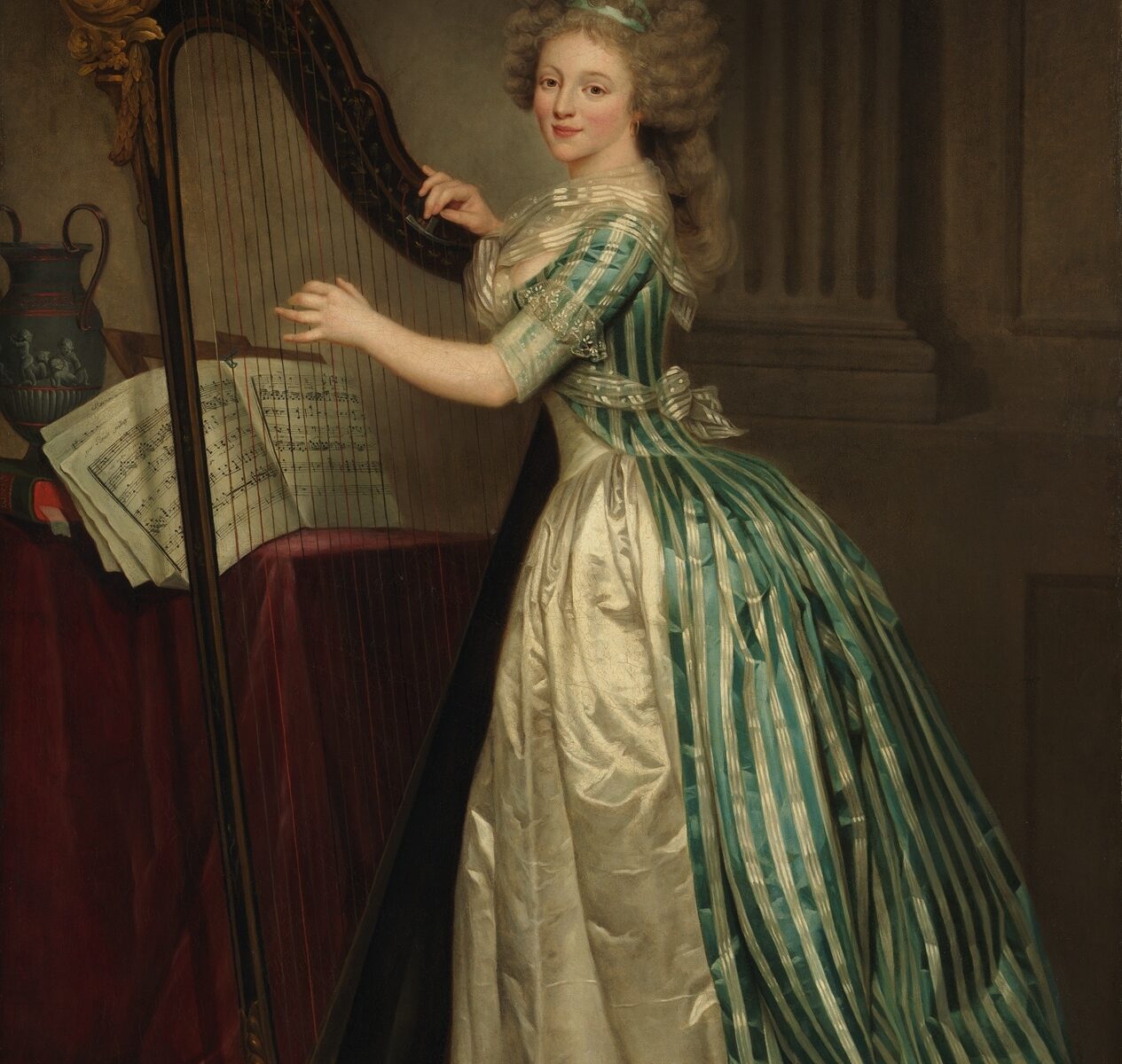
Rose Adélaïde Ducreux, Self-Portrait with a Harp, 1791. Oil on canvas, 76 x 50 3/4 in. The Metropolitan Museum of Art, Bequest of Susan Dwight Bliss, 1966. www.metmuseum.org
Arriving in Port-au-Prince, Rose Ducreux would have rightly considered herself a prominent portraitist of the Salon exhibitions, where she first showed a grand, full-length self-portrait in 1791 (Fig. 1).[5] In an attestation to the Revolutionary government in 1794 appealing to keep shared lodgings in the Louvre, her father had written, “I ask my judges to note the public voice and works that Rose Ducreux has showed at several Salons.”[6] Prior to the Revolution, neither she nor her father could exhibit at the official Salon, for they were not members of the Académie royale de peinture et de sculpture, whose regulations would have been additionally onerous for Rose given the limits set on female membership. Rather, she showed regularly at the Salon de la Correspondence starting in 1786, then consistently at the official Salon from 1791 through 1799.
We can only guess at what compelled Rose Ducreux to leave behind a loving family and successful career. A private passenger on a military ship, perhaps she anticipated the quick solidification of a stable, colonial society in which transplanted Frenchmen and women would commission portraits. Her Self-portrait signals a broader fashionable interest in a world of commodities exchanged globally, but omits obvious references to the Caribbean: the urn resembles Wedgwood sources signaling French Anglomanie of the 1780s, while her striped silk dress originates in the fashion for so-called siamoises, patterns brought from Siam since the seventeenth century. A powerful drawing attributed to Ducreux’s father depicting a Black man, possibly a portrait of Olaudah Equiano, records the family’s intersection with empire and enslavement from Europe, but none of her known works appear to depict persons of color.[7] The distinctly colonial direction taken in Rose Ducreux’s biography coalesces most clearly with her courtship and marriage. An ivory portrait miniature by her father evidently representing her future husband in the early 1790s suggests that their families had known each other for years before.[8] Active in Martinique as early as the seventeenth century, Montgirard’s family held deep connections to French colonialism, and he himself held posts in Dominica, Tobago, Saint Lucy and Guyana before heading to Saint-Domingue. In contrast to this dense professional and family network, colonial France is nowhere obvious in Ducreux’s many surviving paintings or art critics’ reactions to them—though perhaps it need not be and, in fact, the things she sent home in Saint-Domingue are indicative enough. Coffee, sugar and snuff were ephemeral yet everywhere present in her Parisian life. So while nothing so dramatic nor politically entangled as Ducreux’s final year could be predicted by her earlier art or biography, this abrupt lack of transition is perhaps all the more revealing of eighteenth-century Parisian lives and livelihoods, invisible on the surface and yet always already colonial.
[1] Main sources are Georgette Lyon, Joseph Ducreux, premier peintre de Marie-Antoinette, 1735-1802: sa vie, son œuvre (Paris: La Nef de Paris, 1958), esp. 74, 79-80, 111-12; Joseph Baillio, “Une artiste méconnue: Rose Adélaïde Ducreux,” L’Œil, no. 399 (October 1988), 20-27.
[3] I am very grateful to Meredith Martin for this reference and its connection to Montgirard’s wife. Archives nationales d’outre mer, COL F6 5 No. 149B. Dated 23 fructidor year X (August 30, 1802).
[5] Katharine Baetjer, French Paintings in The Metropolitan Museum of Art (New Haven and London: Yale University Press with The Metropolitan Museum of Art, 2019), 350-52 (no. 117). Also see the object file with research by Francesca Whitlam-Cooper and online entry.
[7] While the attribution of this drawing has remained uncertain, it has strong technical and formal similarities to a Head of a Gentleman (ca.1770-80; National Gallery of Art, Washington, 1991.23.2.a) accepted as the work of Joseph Ducreux.
[8] Sold Paris, Hotel Drouot, Binoche et Giquello, March 30, 2012, Lot 91.
Cite this post as: David Pullins, “Always Already Colonial: Rose Ducreux in Port-au-Prince,” Colonial Networks (April 2025), https://www.colonialnetworks.org/?p=772
Collaboration and conversation are central to our Colonial Networks project. On November 8, 2024, we hosted two workshops at NYU’s Center for the Humanities to discuss, critique, and generate new ideas for two project components that we are currently developing. One of these workshops, which Hannah Williams has written about in a separate post, considered how to “unsettle” museum collections and tell new stories about art objects through digital and decolonial approaches to provenance. In the other workshop—discussed here—we explored how to use critical counter-mapping as a tool for 1) subverting dominant narratives of colonial maps of Haiti/Saint-Domingue; and 2) re-ontologizing these maps with stories of Black life and resistance.
We’re grateful that our colleague Christy Pichichero (George Mason University), a leading scholar of French history and Black studies who has led efforts to promote diversity, inclusion, and anti-racism across the humanities, offered to co-organize and run the session with us.
The Silencing of Colonial Maps
The Colonial Networks project grew out of our desire to “map” and examine largely unknown connections between Haiti/Saint-Domingue and the Paris art world during the late 18th and early 19th Centuries. Our starting point for analyzing these connections were late 18th C. colonial property maps of Saint-Domingue, among them René Phelipeau’s plan of the area around the town of Cap-Français (Cap-Haïtien) shown below. The land depicted on this map is divided up into plantation boundaries, all of them bearing the names of mostly white absentee planters, which together read like a “who’s who” of the Paris art world, with the names of major collectors, patrons, dealers, and even artists and architects represented.
Maps like Phelipeau’s, on the one hand, reveal the profound, disturbing links between land ownership and enslavement in Saint-Domingue and the production and consumption of art in the French metropole. But they also occlude the stories of generations of Black men and women who lived, loved, and labored in these spaces and resisted the oppression and erasure they imposed. We want to create an alternative, layered version of this map that acknowledges (following Haitian historian Michel-Rolph Trouillot) its “silencing” of the past while also aiming to center Black and Indigenous geographies and restore some sense of the human and ecological devastation it embodies. While other components of the Colonial Networks project consider how the exploitation of human beings and natural resources in Haiti/Saint-Domingue fueled the growth of the Paris art world, this part of the project focuses on the vibrant visual and material culture of Haiti itself, notably via stories of the many enslaved and free artisans and laborers who played a vital role.
The Workshop: Conversations on Counter-Mapping
Since we (Hannah and I) are not specialists in Caribbean or Haitian history, Black studies, or Black digital humanities, we were very aware of the need to learn from other scholars who have been doing innovative work in these areas. We also wanted to hear from map specialists about the creation and agendas of colonial property maps and from musicologists about how one might reanimate lives and stories through sound. Along with Christy Pichichero, we were honored that so many scholars whose work has inspired our own joined us for this workshop, and we are grateful for their time and input: Arielle Alterwaite (University of Pennsylvania), Marlene Daut (Yale University), Julia Doe (Columbia University), Dani Ezor (Kenyon College), Alex Gil Fuentes (Yale), Jessica Marie Johnson (Johns Hopkins University), Bertie Mandelblatt (John Carter Brown Library), Siobhan Mei (University of Massachusetts Amherst), David Pullins (Metropolitan Museum of Art), and Cloe Gentile Reyes (NYU). We were also joined by members of our NYU-based project team: Lucy Appert, Selin Ozulkulu, and Zhiyang Wang.
Christy started us off with an overview of the field of critical cartography, beginning with Brian Harley’s 1988 essay “Maps, Knowledge, and Power,” whose foundational insights continue to resonate:
Slide showing key themes and quotes from Harley’s essay. Image by Christy Pichichero.
Harley’s observation that European maps actively promoted territorial appropriation and dispossession certainly pertains to the plan by Phelipeau, whose trompe l’oeil frame suggests it could have been hung in a Parisian townhouse and used to flaunt territorial claims by absentee planters. It is biased both in foregrounding the names of mostly French landowners and colonial districts and in suggesting a neat, orderly parceling of space where agricultural exploitation and human habitation is minimized. The presence of the many thousands of enslaved African and Afro-descended laborers who lived on these properties, for instance, is alluded to only by tiny squares denoting slave cabins in neat rows.
Detail of Phelipeau’s plan of Cap-Français depicting cabins for the enslaved (on the property designated “Cte de Vaudreuil”) as well as the names Choiseul, Vergennes, Breda, and others.
The individual lives, struggles, relations, and resistance of these enslaved individuals, who often charted their own counter-geographies and traversed property boundaries in order to share knowledge, build community, and fight oppression, are completely absent. Inspired by the work of several scholars, among them John Garrigus and Catherine MacKittrick, as well as digital humanities projects led and supported by some of our workshop participants (notably Alex Gil Fuentes and Jessica Johnson), we discussed how one might bring these Black lives and geographies to the forefront.
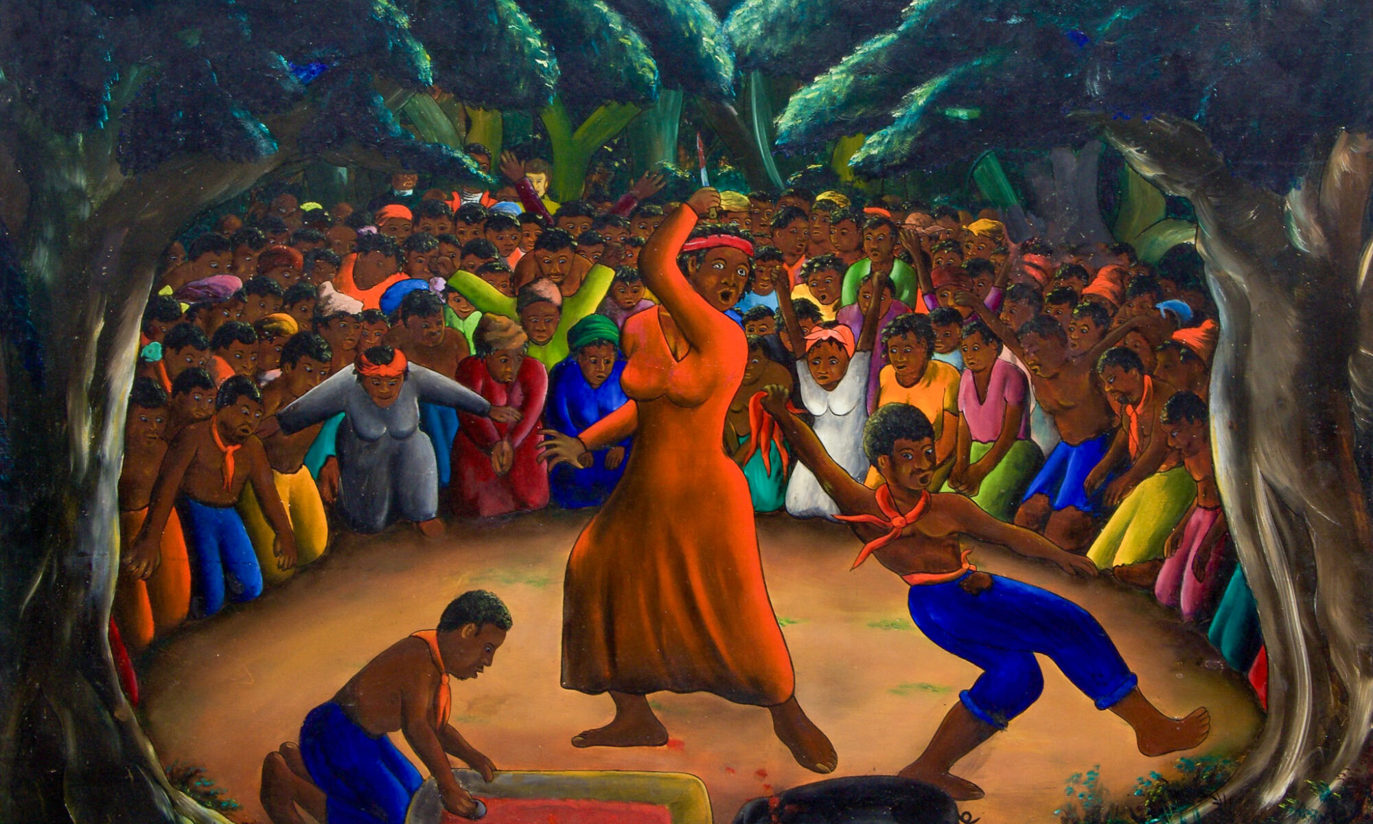
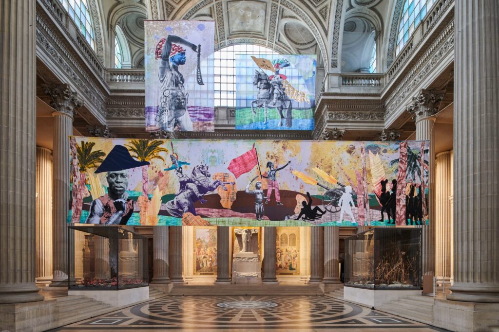
One approach we considered was to feature the work of modern Haitian and Caribbean diasporic artists who reimagine the past by portraying historical events for which we have no surviving visual record. For example: by honing in on just one small slice of our property map, like the detail shown above, we can see plantations “belonging” to such noted Parisian art world figures as Vaudreuil, Choiseul, and the comte de Vergennes. But one could tell a different story by indicating that this was the same territory where Toussaint Louverture was born and lived (on the Breda plantation); where the Bois-Caïman ceremony, a key event precipitating the Haitian Revolution, took place; and where the Battle of Vertières, a decisive turning point in the struggle for Haitian independence, was fought. Many artists have visualized these figures and events, from the 20th C. Haitian painter Jacques-Richard Chéry to the contemporary artist Raphaël Barontini, whose 2023-24 installation at the Paris Panthéon, together with a related exhibition entitled Dare Freedom, filled in important gaps in the Panthéon’s selective vision of Revolutionary liberty.
Jacques-Richard Chéry, Bois-Caïman Ceremony, 1960s. Image source: Haitian Art Society.Raphaël Barontini, We Could Be Heroes, installation view at the Paris Panthéon (with a mural depicting the Battle of Vertières), 2023. Photograph by Benjamin Gavaudo, Mariane Ibrahim Gallery.
Our workshop participants had a range of responses to the cartographic, visual, and archival material we presented. (“I hate that map!” was one of the first ice-breaking responses.) They also had helpful suggestions on how to engage public and community audiences beyond art history, and to bring in Black and Indigenous perspectives. We discussed the importance of forging a dialogue with scholars and stakeholders in Haiti, and of thinking about how our project relates to Haiti’s ongoing crisis today. We aren’t sure what our critical counter-map will ultimately look like. It might resemble a pilot project created in Fall 2024 with graduate students from NYU’s Institute of Fine Arts, although we may use a different format as well as animation and sound elements. But as one of our participants noted at the end of the session, the only way forward is to start doing the work, to acknowledge self-doubts and limitations, and to welcome advice and help when it’s offered.
Cite this post as: Meredith Martin, “Black Geographies of Art in Haiti/Saint-Domingue: A Workshop on Critical Counter Maps and Digital Humanities,” Colonial Networks (February 2025), https://www.colonialnetworks.org/?p=755
One of the key collaborative activities of our 2024 program for the Colonial Networks project were two workshops we ran at NYU’s Center for the Humanities on November 8, 2024. This post is about the workshop we titled Unsettling Collections: The Paris Art World and Haiti/Saint-Domingue, which brought together a group of museum curators, scholars, auction house specialists, and collections researchers to imagine new ways of telling stories about French art through digital approaches to provenance histories.
The other workshop we ran that day was titled Critical Counter-Mapping Black Geographies of Art in Haiti/Saint-Domingue, and we’ve written about that in a separate note.
Unsettling Collections
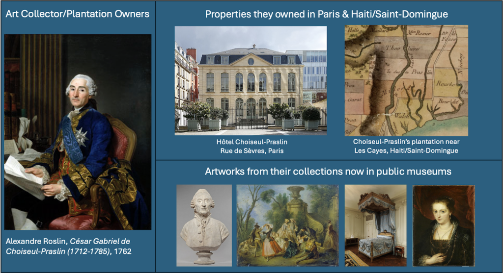
The idea for “unsettling collections” came out of the branch of our project focused on Connecting Paris & Haiti/Saint-Domingue, which explores the profound links between members of the eighteenth-century Paris art world and their colonial activities in Haiti/Saint-Domingue. One of the main components we’ve been researching is plantation owners and colonial administrators who are now better known (among French art historians, at least) as important French art collectors, among them the comte de Vaudreuil (1740-1817), Jean-Joseph de Laborde (1724-1794), and members of the extended Choiseul family. We’re comparatively mapping the properties these people owned in Paris and in Haiti/Saint-Domingue, researching their activities as enslavers and the wealth they generated from colonial commerce, and tracing the vast number of artworks from their collections that, owing in part to the upheavals of the French and Haitian Revolutions, ended up in public museums throughout Europe and the U.S. The screenshot below is a slide that visually summarizes the material intersections of this research into people, property, and objects.
Slide showing the intersections of this research into people, property, and obects using examples from the case of César Gabriel de Choiseul Praslin (1712-1785). Image by Hannah Williams.
One result of this research is a growing dataset of eighteenth-century French artworks which are—as a result of their provenance stories—directly or indirectly implicated in the disturbing colonial histories of Haiti/Saint-Domingue. As much as this research “unsettles” the histories of these eighteenth-century Parisian art collections, it also provides an opportunity to productively disrupt and reorient the current museum collections in which these objects now reside.
That was the objective behind the Unsettling Collections workshop: exploring with curators how we can tell new stories and engage new audiences through reimagined approaches to provenance – and vitally – how digital spaces and opportunities might address some of the many challenges posed by such an endeavor.
The Workshop: Conversations and Thoughts
We invited a group of curators and collections researchers, all of whom either work in museums that currently hold objects from our dataset, or who work with colonial provenance in some way. We’re extremely grateful to these colleagues for generously sharing their time, expertise, and creativity to come together and exchange ideas: Taylor Alessio (Christie’s); Esther Bell (Clark Art Institute); Marie-Laure Buku Pongo (The Frick Collection); Laura Sofia Hernandez Gonzalez (Museo de Arte de Ponce); Yuriko Jackall (Detroit Institute of Art); Elyse Nelson (Metropolitan Museum of Art); Guillaume Nicoud (Archivio del Moderno, Università della Svizzera Italiana); Christy Pichichero (George Mason University); David Pullins (Metropolitan Museum of Art); and Perrin Stein (Metropolitan Museum of Art). The other workshop participants were ourselves (Meredith Martin and Hannah Williams) and members of our NYU-based project team: Lucy Appert, Selin Ozulkulu, and Zhiyang Wang.
Collectively, the provenance histories of the artworks in our dataset reveal crucial insights into connections among the French metropolitan art world, colonial economies, and enslavement in the eighteenth century. But these are often difficult to stories to tell within the gallery, or even within a single institution.
Within the gallery, provenance stories aren’t always the most pertinent details to foreground in the restricted modes of in-gallery interpretation available. For example, the comte de Vaudreuil owned two paintings that are now in the collection of the Metropolitan Museum of Art in New York: Elisabeth Vigée Le Brun’s Julie looking in a Mirror of 1787 and Bartholomeus Breenbergh’s Preaching of John the Baptist of 1634. Vaudreuil was friends with Vigée Le Brun, and the two (along with Vigée Le Brun’s art dealer husband) were key figures in what we’re calling the “colonial networks” of the Paris art world. So in the case of the Met’s Vigée Le Brun painting, its provenance connections to Vaudreuil and his enslaving activities, which formed the basis for his wealth, would be a highly relevant detail for inclusion in a wall label, providing a crucial aspect of its history for museum visitors. But it’s quite different in the case of the Breenbergh painting. For this seventeenth-century religious landscape by a Dutch artist, which wasn’t acquired by Vaudreuil until over a century after it was made, this episode or “event” from its longer provenance history is not the most relevant detail to include on a wall label for contemporary museum visitors.
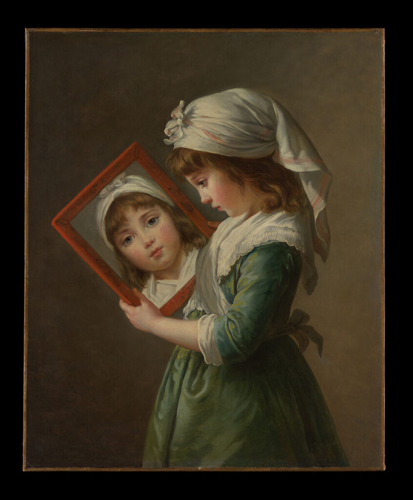
Elisabeth Vigée Le Brun, Julie Le Brun Looking in a Mirror (1787). Metropolitan Museum of Art, New York, https://www.metmuseum.org.Bartholomeus Breenbergh, Preaching of John the Baptist (1634). Metropolitan Museum of Art, New York, https://www.metmuseum.org.
These complex stories are also difficult to tell within a single institution, not least due to the vast dispersal of these objects after they left their eighteenth-century collections. Vaudreuil’s artworks, for instance, are now held in scores of museums around the world, including the Met in New York, the National Galleries of Art in London and in Washington, D.C., the Wallace Collection in London, the Musée du Louvre in Paris, and the Museo de Arte de Ponce in Puerto Rico (to name but a few).
Digital approaches can provide scope for overcoming these kinds of challenges, and that was the focus of our conversations in the workshop. We discussed the role that provenance—typically presented as a dry, highly systematized list of names whose stories and significance are not evident to most readers—plays in different kinds of museum interpretation (from the wall label to the museum website), and we considered examples of objects with provenances tied to French histories of colonialism and enslavement and how these links are currently communicated (or not). Throughout the workshop, lots of valuable comments and ideas were raised about the needs and interests of different audiences, the political pressures that museums face, and the vast potential of museum websites and social media channels as a space to animate provenance and, in so doing, to complicate and enrich the lives of objects.
Building on these valuable and on-going conversations with curators, we are currently working with our digital team to prototype one approach to animating provenance in this way, working with some key objects that have emerged from our research.
Cite this post as: Hannah Williams, “Unsettling Collections: A Workshop with Museum Curators and Collections Researchers,” Colonial Networks (January 2025), https://www.colonialnetworks.org/?p=628


